Back شارع بنسلفانيا (واشنطن) Arabic Pennsylvania Avenue German Avenida Pensilvania (Washington D. C.) Spanish خیابان پنسیلوانیا Persian Pennsylvania Avenue Finnish Pennsylvania Avenue French שדרות פנסילבניה HE Pennsylvanijska avenija Croatian Pennsylvania Avenue Hungarian Փենսիլվանիա (պողոտա) Armenian
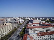
 Pennsylvania Avenue with the U.S. Capitol in the background | |
| Length | 35.1 mi (56.5 km) |
|---|---|
| Location | Washington, D.C. and Prince George's County, Maryland, U.S. |
Pennsylvania Avenue is a primarily diagonal street in Washington, D.C. that connects the United States Capitol with the White House and then crosses northwest Washington, D.C. to Georgetown. Traveling through southeast Washington from the Capitol, it enters Prince George's County, Maryland, and becomes MD Route 4 (MD 4) and then MD Route 717 in Upper Marlboro, and finally Stephanie Roper Highway.
The section of the avenue between the White House (which is sometimes referred to by its address, "1600 Pennsylvania Avenue") and Congress forms the basis for the Pennsylvania Avenue National Historic Site and is sometimes referred to as "America's Main Street";[1] it is the location of official parades and processions, and periodic protest marches. Pennsylvania Avenue is an important commuter road and is part of the National Highway System.[2][3]
- ^ Pennsylvania Avenue, National Historic Site Archived 2010-08-30 at the Wayback Machine. National Park Service.
- ^ United States. Congress. Senate. Committee on Appropriations. Subcommittee on Transportation and Related Agencies (1995). Department of Transportation and Related Agencies Appropriations for Fiscal Year 1995. U.S. Government Printing Office. p. 142. ISBN 978-0-16-046724-0. Archived from the original on March 3, 2023. Retrieved May 9, 2018.
- ^ Scot Schraufnagel (August 11, 2011). Historical Dictionary of the U.S. Congress. Scarecrow Press. p. 166. ISBN 978-0-8108-7455-8. Archived from the original on March 3, 2023. Retrieved May 9, 2018.
© MMXXIII Rich X Search. We shall prevail. All rights reserved. Rich X Search